|
|
| GIS |
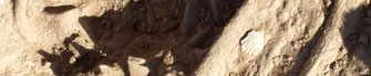
 The handling of the data collected during an archaeological excavation is a complicated and laborious task that demands careful planning and archival organisation. In the last few years the use of computers has helped the documentation of excavations a great deal by offering more flexibility than conventional methods (e.g. excavation diaries, finds catalogues, etc.). Geographic Information Systems (GIS) have played an important role in this development. The handling of the data collected during an archaeological excavation is a complicated and laborious task that demands careful planning and archival organisation. In the last few years the use of computers has helped the documentation of excavations a great deal by offering more flexibility than conventional methods (e.g. excavation diaries, finds catalogues, etc.). Geographic Information Systems (GIS) have played an important role in this development. |
| |
| GIS |
|
GIS are a revolutionary way of organising and processing data, since they have the capability of handling different forms of information (text, drawings, photographs, etc.) and to combine them into a single product in map form. In this way the lengthy and detailed examination of the spatial relationships is made possible, as is the creation of maps in a digital environment which can be saved and then investigated further. |
|
| Documenting excavations |
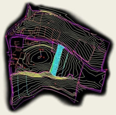
| The basic stage for the exploitation of the capabilities of GIS is the digitising of excavation data. All the information collected during the excavation is recorded in an electronic database, while the photographs of the trenches are taken with a digital camera and are photogrammetrically corrected by specialist topographers. The plans of the excavation are created by manipulating the photographs using computers and specialised topographic programs (AutoCAD). All of the above are combined with the general topographic plan of the site, the geophysical study and the aerial photographs of the region in their actual dimensions, allowing greater freedom for analyses at the levels of both the excavation and the landscape. |
| |
| Analysis of excavation data |
| At the excavation level, GIS allow the visualisation of ancient data in space and their interrelation with the use of statistical methods. In addition, the graphic environment allows the creation of two- or three-dimensional digital reconstructions of the archaeological space, which are open to analysis and visual checks. In this way, relationships between the data of the archaeological study can be uncovered, relationships which would have been very difficult to notice using conventional methods. |
| |
| Analysis of the landscape |
| At the landscape level, an effort is being made to produce new digital maps of the area, which will form the foundation for the organisation of the data collected during the systemic study of the changes in the environment and topography. Once the cartographic, environmental and archaeological data have been incorporated various questions can be approached, such as the diachronic morphology of the settlement and the exploitation of the area, and the digital reconstruction of the ancient and recent topography can be undertaken. |
| |
| Aim |
| To this end, the creation of an original system is being planned which will act as the search engine for all the excavation data, and as an analytical tool in a cartographic environment. Through the combination of multimedia systems and GIS the excavation data will be accessible both at the level of relationships and at the level of a map. The system will allow researchers to explore the relationships between data, and will allow the visualisation of the selected relationships in the digital environment, thus offering the fullest possible image of excavation. |
|
|