|
|
| Site |
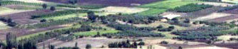
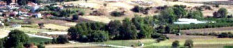
| The area at Paliambela officially declared an archaeological site is situated right next to the modern village, to the east. It is a low hill in the middle of a valley crossed by two streams flowing eastwards on each side of the hill. It has a panoramic view of the wider plain down to the surrounding hills and to the coast in the east. The site resembles the known mounds in Thessaly and Macedonia, although its prominence in relation to the surrounding landscape is less pronounced. |
| |
| History of the site |
 The archaeological site belongs to the community ever since the refugees of 1923 were settled there. During the land redistribution at 1934, the land in the area was divided among the inhabitants of Paliambela, except for the hill which was set aside as a public space for the foundation of a school, which later took up a piece of the hill. Following the discovery of the prehistoric settlement most of the hill was declared an archaeological site. Until the start of the archaeological research, the area had been used for cultivation. Various accounts tell of a number of concentrations of stones on the hill in the past which probably belonged to older Byzantine structures, but these were removed given their usefulness as a convenient building material. The continued use of the area for cultivation completely destroyed any remaining traces of these constructions, and it also seems to have affected the underlying prehistoric levels. The archaeological site belongs to the community ever since the refugees of 1923 were settled there. During the land redistribution at 1934, the land in the area was divided among the inhabitants of Paliambela, except for the hill which was set aside as a public space for the foundation of a school, which later took up a piece of the hill. Following the discovery of the prehistoric settlement most of the hill was declared an archaeological site. Until the start of the archaeological research, the area had been used for cultivation. Various accounts tell of a number of concentrations of stones on the hill in the past which probably belonged to older Byzantine structures, but these were removed given their usefulness as a convenient building material. The continued use of the area for cultivation completely destroyed any remaining traces of these constructions, and it also seems to have affected the underlying prehistoric levels. |
| |
| Current situation |
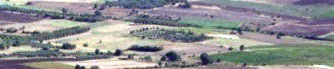
| In the north-eastern part of the site there is a small modern cemetery belonging to the village, while to the north the site is cut by the road leading to the village. To the north-west lies the village church, and the school with its yard and basketball court, which has since been converted into the excavation headquarters. In the south-west are some village houses, and to the south the hill is cut abruptly due to the nearby river. Surface finds collected from the areas between the houses of the village attest the extension of the site to the west. Thus two areas can be distinguished: the first to the east on the hill (the official archaeological site), and the second to the west on the flat level of the village. The archaeological survey is limited to the eastern section. |
|
|
| |
| Plans for the future |
In contrast to the situations of the majority of other archaeological sites, the land around the excavation is not subject to strong pressures from tourism or traffic. The foundation of the archaeological park will contribute to the conservation of the form of the mound, since every intervention in the space will be made with respect for the surrounding area and its history. Since the agricultural character of the area constitutes a linking element between the past and the present, the wider natural landscape will be supported, and protected from any possible alterations. |
|
|